中国综合性科技类核心期刊(北大核心)
中国科学引文数据库来源期刊(CSCD)
美国《化学文摘》(CA)收录
美国《数学评论》(MR)收录
俄罗斯《文摘杂志》收录
中国综合性科技类核心期刊(北大核心)
中国科学引文数据库来源期刊(CSCD)
美国《化学文摘》(CA)收录
美国《数学评论》(MR)收录
俄罗斯《文摘杂志》收录
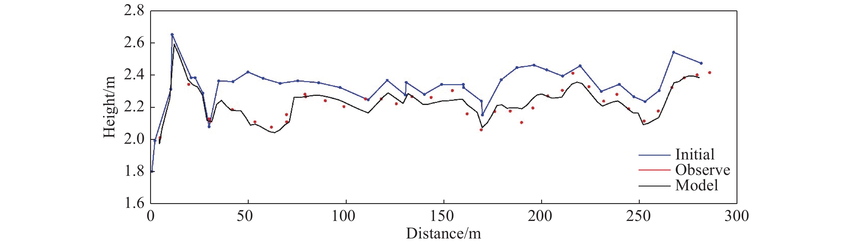
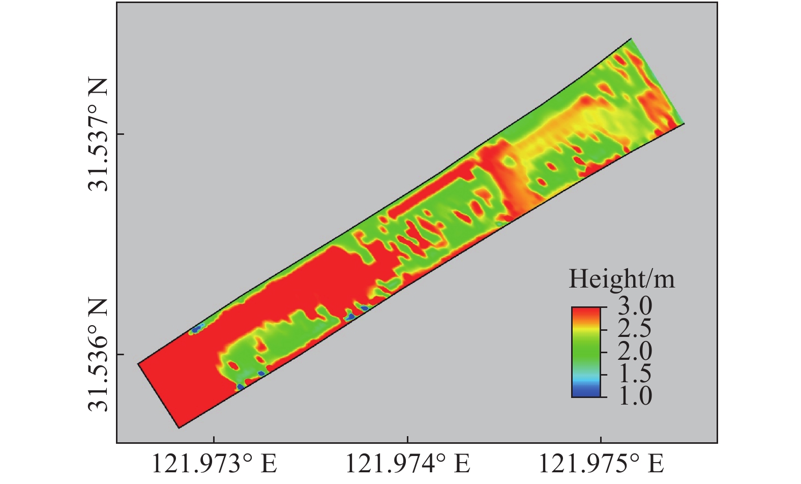
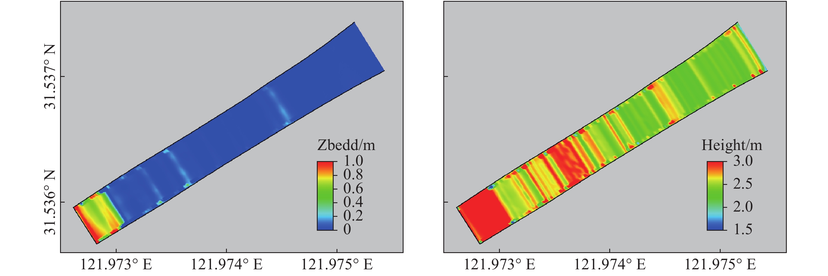
| Citation: | LU Peiyi, ZHU Jianrong, QIAN Weiwei, YUAN Lin. Numerical simulation of erosion and deposition at the water intake channel of the outer seawall sluice in the ecological restoration project area of Chongming Dongtan Bird Habitat[J]. Journal of East China Normal University (Natural Sciences), 2020, (3): 43-54. doi: 10.3969/j.issn.1000-5641.201941013

|

| [1] |
杨元平, 唐子文, 史英标. 曹娥江大闸闸下淤积现状分析及减淤对策初探 [J]. 浙江水利科技, 2013(2): 35-39. DOI: 10.3969/j.issn.1008-701X.2013.02.008.
|
| [2] |
金元欢, 沈焕庭. 我国建闸河口冲淤特性 [J]. 泥沙研究, 1991(4): 59-68.
|
| [3] |
李大山, 任汝述. 波浪作用下异重流运动特性研究 [J]. 海洋工程, 1996(4): 54-59.
|
| [4] |
窦国仁. 窦国仁论文集 [M]. 北京: 中国水利水电出版社, 2003.
|
| [5] |
伍冬领, 林炳尧, 余大进, 等. 永宁江枢纽引航道和挡潮闸闸港冲淤研究 [J]. 泥沙研究, 2003(2): 69-72. DOI: 10.3321/j.issn:0468-155X.2003.02.012.
|
| [6] |
曲红岭, 窦希萍, 赵晓冬, 等. 不同类型建闸河口闸下淤积模拟计算 [J]. 海洋工程, 2011, 29(2): 59-67. DOI: 10.3969/j.issn.1005-9865.2011.02.009.
|
| [7] |
成建, 刘德荣. 浅析闸下港道淤积及治理问题 [J]. 山东水利, 2011(7): 24-26. DOI: 10.3969/j.issn.1009-6159.2011.07.011.
|
| [8] |
徐雪松, 窦希萍, 陈星, 等. 建闸河口闸下淤积问题研究综述 [J]. 水运工程, 2012(1): 116-121. DOI: 10.3969/j.issn.1002-4972.2012.01.024.
|
| [9] |
王文杰. 海泊河挡潮闸泥沙模型试验研究 [D]. 山东 青岛: 中国海洋大学, 2012.
|
| [10] |
朱明成. 江苏淤涨型海岸闸下淤积问题初探 [J]. 江苏水利, 2014(6): 11-12.
|
| [11] |
钱建平, 严琴琴, 夏栩. 小洋口闸下港槽淤积分析 [J]. 中国水运, 2014, 14(11): 307-309.
|
| [12] |
陈其美. 新洋港闸下港道淤积分析及对策 [J]. 水利建设与管理, 2009, 29(9): 57-59. DOI: 10.3969/j.issn.1005-4774.2009.09.024.
|
| [13] |
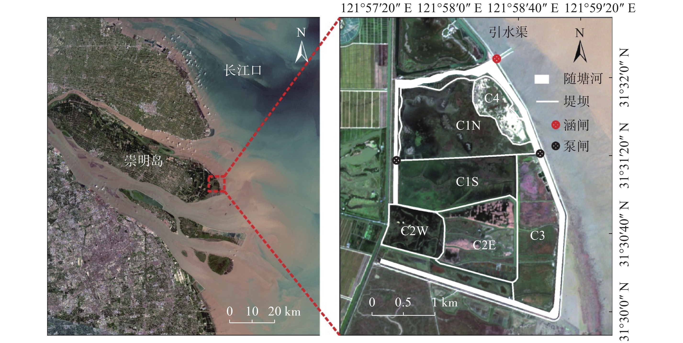
孙振华, 虞快. 崇明东滩鸟类自然保护区的建立及其意义 [J]. 上海建设科技, 1998(4): 24-26.
|
| [14] |
孙鸿雁, 唐芳林, 周红斌, 等. 上海崇明东滩鸟类国家级自然保护区总体规划的启示 [J]. 林业建设, 2013(1): 22-26.
|
| [15] |
BLUMBERG A F, MELLOR G L. A description of a three-dimensional coastal ocean circulation model [G]// HEAPS N S. Three-Dimensional Coastal Ocean Models. Washington, DC: American Geophysical Union, 1987: 1-16.
|
| [16] |
QIU C, ZHU J R. Influence of seasonal runoff regulation by the Three Gorges Reservoir on saltwater intrusion in the Changjiang River Estuary [J]. Continental Shelf Research, 2013, 71: 16-26. DOI: 10.1016/j.csr.2013.09.024.
|
| [17] |
LYU H H, ZHU J R. Impact of the bottom drag coefficient on saltwater intrusion in the extremely shallow estuary [J]. Journal of Hydrology, 2018, 557: 838-850. DOI: 10.1016/j.jhydrol.2018.01.010.
|
| [18] |
LI L, ZHU J R, WU H. Impacts of wind stress on saltwater intrusion in the Yangtz Estuary [J]. Science China Earth Sciences, 2012, 55(7): 1179-1192.
|
| [19] |
LI L, ZHU J R, WU H, et al. A numerical study on the water diversion ratio of the Changjiang Estuary during the dry season [J]. Chinese Journal of Oceanology and Limnology, 2010, 28(3): 700-712. DOI: 10.1007/s00343-010-9114-2.
|
| [20] |
朱建荣, 吴辉, 顾玉亮. 长江河口北支倒灌盐通量数值分析 [J]. 海洋学研究, 2011, 29(3): 1-7. DOI: 10.3969/j.issn.1001-909X.2011.03.002.
|
| [21] |
QIU C, ZHU J R. Assessing the influence of sea level rise on salt transport processes and estuarine circulation in the Changjiang River Estuary [J]. Journal of Coastal Research, 2015, 31(3): 661-670.
|
| [22] |
刘高峰. 长江口水沙运动及三维泥沙模型研究 [D]. 上海: 华东师范大学, 2011.
|
| [23] |
曹祖德, 王运洪. 水动力泥沙数值模拟 [M]. 天津: 天津大学出版社, 1994: 241-249.
|
| [24] |
罗志发. 长江口及其邻近海域泥沙输运及其动力机制 [D]. 上海: 华东师范大学, 2018.
|
| [25] |
LIANG B C, LI H J, LEE D Y. Bottom shear stress under wave-current interaction [J]. Journal of Hydrodynamics Ser B, 2008, 20(1): 88-95. DOI: 10.1016/S1001-6058(08)60032-3.
|
| [26] |
吴宇帆. 长江河口细颗粒泥沙沉降速度研究 [D]. 上海: 华东师范大学, 2016.
|
| [27] |
刘红, 何青, 吉晓强, 等. 波流共同作用下潮滩剖面沉积物和地貌分异规律——以长江口崇明东滩为例 [J]. 沉积学报, 2008(5): 833-843.
|
| [28] |
戴苒, 朱建荣. 长江口崇明东滩风况统计分析 [J]. 华东师范大学学报(自然科学版), 2015(4): 17-25.
|
| [29] |
庞启秀, 白玉川, 杨华, 等. 淤泥质浅滩泥沙临界起动切应力剖面确定 [J]. 水科学进展, 2012, 23(2): 249-255.
|
| [30] |
赵振兴, 何建京. 水力学 [M]. 2版. 北京: 清华大学出版社, 2010: 176.
|
| [31] |
戴苒. 长江河口河床泥沙临界起动应力空间分布 [D]. 上海: 华东师范大学, 2016.
|
Figures(11)


 DownLoad: